
To further your research in
Armstrong County,
try these titles below.
For general information and books about Pennsylvania, or to locate information about other counties, visit the
Pennsylvania Page of Time Voyagers Bookstore
Don't forget to check on the parent county from which a county was originally founded.
Click here for useful links to historical and genealogical research.
|
History of Armstrong County
Before 1740 Pennsylvania traders had established posts in the Indian villages of the area; and in 1749 Celoron de Blainville, a French army officer, was commissioned by the governor-general of France to claim the region for Louis XV by burying lead plates along the Allegheny River.
The county seat of Kittanning, whose name was derived from the Indian word for "at the great stream," was laid out on a famous Delaware and Shawnee Indian settlement which was claimed by the Six Nations by conquest. This Indian village is believed to have been one of the largest of its kind west of the Alleghenies. On September 8, 1756, during the French and Indian War, Armstrong’s forces destroyed the settlement on account of atrocities the Indians committed against the English. (One of the earliest medals executed in American depicts this event, the die having been cast in Philadelphia in 1756 or 1757.) Among those killed was the Delaware Indian Captain Jacobs, who lived in a two-story log house in Kittanning (site at 313 Market Street).
Blanket Hill, east of Kittanning, was a stopping point for troops en route to attack the Indians and the site of an army defeat when a returning party encountered an large Indian force. A monument marks the hill where the soldiers suffered severe losses and abandoned their blankets and other gear. Fort Appleby, built in 1776 at the site that later became Fort Armstrong was the first United States fort west of the Alleghenies.
Kittanning, together with Ford City and Rosston, was included in Appleby Manor--surveyed in 1769 and one of the forty-four manors reserved by the Penns. The county seat was laid out about 1803-04 and incorporated in 1821. It was the terminal point of the old Frankstown Path (locally called the Kittanning Path), which was used by both the Indians and the settlers for years and was part of a national system of trails, following much the same course from Shelocta to Kittanning as present-day US 422. Other principal Indian trails of the country included the Great Shamokin Path, which followed Cowanshannack Creek most of the way from Kittanning to about Nu Mine, thence turning northeast through Barnards, toward Smicksburg; the Kuskusky Path, running from Kittanning past Worthington, thence toward Herman; and the Kiskiminetas Path, a branch of the Frankstown Path, which cut off east of Shelocta, entered the county near West Lebanon, and followed a course similar to SR 0056 through South Bend and Spring Church, thence running directly to the Indian town of Kiskiminetas on the river northwest of Vandergrift. (The Baker Trail, a modern hiking path originally starting at Freeport and covering seventy-five miles to Cook Forest, was founded in 1950 by the Pittsburgh Council of the American Youth Hostels.)
Freeport, originally Todd’s Town, was laid out by David Todd in 1796. It was traversed by the western division of the Pennsylvania Canal and is the oldest non-Indian town in the county. In the Freeport cemetery (junction of SR 0028 and SR 0356, north of Freeport) is the grave of Massa Harbison.
Among other early settlers of the county were James Clark, William Green, James Kirkpartrick, Michael Mechling, James Claypool, Andrew Sharp, and Absalom Woodward. Others figuring prominently in the county’s history were Edward Warren, who established a trading post near what is now Apollo (Conrad Weiser stopped there on his way to "kindle the first council fire with the Ohio Indians"); Captain Samuel Brady, who was active in frontier campaigns against the Indians; Governor William Freame Johnston; Nellie Bly (Elizabeth Cochrane), one of America’s great reporters; Dr. David Alter, inventor of Spectroscopy, and Margaret Shoemaker, an early feminist.
Natural resources in the area include bituminous coal, clay, salt, oil, gas, sand and gravel, and limestone. Among the principal industries are coal mining, brickmaking, agriculture, lumbering, and iron and steel-sheet manufacture. Brady’s Bend was the site at which the first iron rails west of the Alleghenies were manufactured. The county had 15 early blast furnaces. In 1881 the first visible typewriter was invented in Kittanning by J.D. Daugherty and manufactured there for a number of years.
Two flood control dams in the county form the Mahoning Creek and Crooked Creek reservoirs. The river park at Kittanning is one of the most beautiful waterfronts in western Pennsylvania. At Canal Street in Apollo are the remains of a canal lock.
Source: A Guidebook to Historic Western Pennsylvania
by George Swetnam
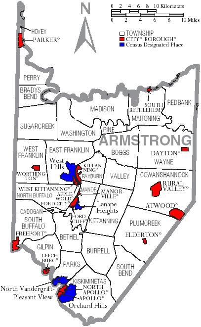
Map of Armstrong County, Pennsylvania, United States with township and municipal boundaries is taken from US Census website and modified by Ruhrfisch in April 2006.
|


 Pennsylvania List of Counties