As the city grew, a rolling mill was added, a silk mill, ice plant, planing mills, soap, broom and brush factories, harness and saddlers' shops, feed mills and retail shops. Persons with talents in other fields were imported from other areas to work for the railroad. Entertainment and recreation facilities were set up by the company. Several railroad bands were formed. A railroad YMCA and a Mechanics Library were built and staffed. Many churches were built and flourished in the city.
A grand hotel, known as the Logan House, was constructed (in the area of the Robeson farm) by the Pennsylvania Railroad in order to accommodate travelers on their journeys from Pittsburgh to Philadelphia. It had one-hundred-two rooms, two large parlors and an excellent dining room. It is said by many that the food was the best in the Commonwealth of Pennsylvania and the ice cream served was the best that money could buy.
A goodly number of the young men of Altoona were engaged in the military during the early years of the railroad as the Union forces were called upon to defend their freedoms against the southern army. By late summer of 1862, the cause of the North seemed to ebb, causing much concern of Gov. Andrew Curtin of Pennsylvania. He invited the governors of the various states to a conference at the Logan House to unite the war effort and chart a course of loyalty to President Abraham Lincoln. It was deemed a success and a delegation was dispatched to Washington to deliver the message personally to President Lincoln. It is said that this support was largely responsible for the favorable turn of events for the Union cause.
By 1924 the population of Altoona was estimated at sixty-seven thousand persons and by 1944 the population had reached 82,000.
During World War II, the military moved many troop trains and equipment by way of the Pennsylvania Railroad through the Altoona area. A canteen was set up near the Altoona station to serve refreshments to service men and women who were passing through town.
Following World War II, there was a program of action to find employment for returning service men and women known as "Jobs for Joes" which was successful in placing former military personnel in the workplace. Later another program was implemented for a revitalization of the area's business community after the decline of the railroad.
Altoona celebrated its Sesquicentennial in 1999.
BARBARA (see Clappertown)
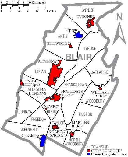
BELLWOOD, or BELLS MILLS as it was once known, was founded by Edward "Neddy" Bell about 1800. A grist mill was built. About 1832 Edward Bell and his son, Martin became interested in the iron industry and built a furnace which they named for Edward Bell's daughter, Elizabeth. The ruins of this furnace are still visible today. Martin Bell devised a system of using escaping gasses from the iron furnace to give added power to the operation and secured a patent for the process. John Bell owned Mary Ann Forge and the Isetts owned Cold Spring Forge.
The Bells Gap Railroad, a narrow gauge road, was built and put into operation in 1872. Its main function was to bring coal and lumber to the main line of the Pennsylvania Railroad. The railroad extended from Lloydsville to Bellwood, a descent of eleven hundred feet in the nine miles of track. In the 1880's it was widened to standard gauge and by 1891 had been extended to Fordham. In 1892 it merged with other lines and became known as the Pennsylvania and Northwestern Railroad. Although abandoned a number of years ago, the bed of the railroad makes an excellent hiking trail with its deep gorges and mountainous slopes. It is truly a spot of beauty.
Incorporation of the Borough of Bellwood occurred on February 9, 1888. Trolley service was initiated into the borough on July 1, 1894. It was later replaced by bus service.
Bellwood is a progressive community. During the past years many improvements have been made in the borough. A fine library has been built and provides excellent service to the community.
BERYL is located in Allegheny Township near the village of Cross Keys and Carson Valley.
BENNINGTON is located near the Cambria County line in Allegheny Township. An iron furnace was located here and a hundred men were employed prior to 1898. The Kittanning and Cambria Iron and Coal Companies operated mines in this area. A short distance away the railroad saw a disastrous wreck of the Red Arrow train in 1947.
BLAIR FOUR is located in Catherine Township five miles east of Williamsburg. There was an iron furnace and limestone industry here. Remains of the furnace still remain.
BLAIR FURNACE An iron furnace was located here. It was located at East Altoona in Logan Township.
BLUE KNOB is located in Juniata Township. It is adjoining the Bedford County line. The community was engaged in agriculture and lumbering for many years. A ski resort is now operated at Blue Knob.
CANOE CREEK is located in Frankstown Township. The remains of the old limestone furnaces are here as a reminder that it was once an industrial site for the preparation of limestone to be used in the iron industry. A State Park is the recreational facility located here.
CHARLOTTESVILLE is a small village in Antis Township near Tipton.
CLAPPERTOWN formerly known as Barbara as Clappertown and is located in Huston Township and was established in an agricultural district. Mining of iron ore and a smelting furnace were located here.
CLAYSBURG was an early settlement at the eastern end of Greenfield Township. The first settlers were Valentine Lingenfelter and his two sons who were here about 1770. Shortly after their arrival, the Dively family settled here and soon to follow were Thomas Ives and John Nicholas. Following the Revolutionary War many settlers arrived from the east and south. About 1804, John Ulrich Seth cleared some of the land and put up a saw mill and grist mill.
Dr. Peter Shoenberger settled one mile south of Claysburg and operated the Sarah Furnace at Sproul. The furnace operated for some few years and was unsuccessful. Thus there was no public works in the Claysburg area until the cobblestone road was built through town about 1906-07.
An early school was built near the limestone quarry, south of Claysburg about 1795. A second school was built in 1812. It was a log building with a clapboard roof and slab benches. James Lonham was the teacher. Rules were strict for teachers in those days. One of the rules was that gentlemen teachers may take one evening a week for courting purposes or two evenings a week if they went to church regularly. Teachers who performed their labors well and without fault for five years were given an increase of twenty-five cents per week in pay providing the Board of Education approved.
Following the completion of the State road and the railroad in 1910, outside interest grew in the Claysburg area. The area of Sarah Furnace was now the site of a brick plant by 1911 and in 1913 a brickyard was constructed north of town. General Refractories Company who owned these brickyards employed about twelve hundred men and products were among the finest in the United States.
COVE FORGE is located in Catherine Township about five miles east of Williamsburg. For many years people engaged in the iron industry lived here but it is basically an agricultural community.
CULP is located in Tyrone Township and named for a family of the district.
CURRYVILLE was founded as a railway freight and passenger station in 1872. Its principal business is dairy and feed products. It is located in the agricultural area of the County and provides produce used in many areas.
DRAB is now known as Beavertown and is located in Huston Township on the Clover Creek highway between Williamsburg and Fredericksburg.
DUNCANSVILLE lies along the route of the old Philadelphia-Pittsburgh turnpike. Once the town was a beehive of activities with the iron industry and received the nickname "Irontown" when forges, iron mills and foundries were the communities industries. Not to be ignored were the woolen mills, wagon works, grist mills and lime production.
Ground was acquired and laid out by Samuel Duncan and Jacob Walters. Duncan named his plot west of the Blair's Creek, Duncansville while Walters land on the east side of the stream was named Walterstown. A bridge at the stream connected the two villages. There was considerable confusion and rivalry between Duncan’s section of town and Walterstown. To settle the issue Duncan and Walters agreed to choose a common name. It was decided that they would meet on the bridge which separated the plots and by the toss of a coin decide that the entire area would be named for Duncan or Walters. A large crowd gathered on both sides of the bridge for the toss of the coin. Duncan won and thus Walterstown was part of Duncansville.
In the 1840's a forge was built which was later transformed into a rolling mill. By 1882 the iron industry was a booming business. In 1896 the rolling mill company began construction of a wire mill. When production flourished the mill produced more than four hundred kegs of finished nails daily. The mill closed in 1904. Another industry which flourished for many years in the community was the manufacturing of bricks.
Duncansville was incorporated as a borough on March 4, 1891. About 1930 a large airport was established and existed for a number of years. One of the nations first air mail pick-up systems was initiated here whereby a plane could pick-up and dispatch mail by special device without landing the plane.
EAST FREEDOM was first established as Three Forges in Bedford County in February 1829. When Blair County was established, the name was changed to East Freedom. In the early days, it was an important center for travel and transportation. Now surrounded by a number of businesses and highways, it presents some of the most beautiful scenery in Blair County.
EAST SHARPSBURG is located one and a half mile south of Roaring Spring.
ELBERTA was established as Bushman and changed to Elberta in 1906. It is about six miles from Altoona in the Sinking Valley area.
FOSTORIA is located along the main line of the Pennsylvania railroad near Tyrone.
FRANKSTOWN is probably the oldest name of a town in the county. Legend says that it was named for Francois Etienne (Frank Stevens) who was of French descent and had a trading post there before white men lived in the area. Supplies and weapons were traded for meat and furs with the Indian tribes. By 1800 Frankstown contained about twenty houses and several taverns and was considered an important business center due to its location on the Huntingdon, Cambria and Indiana turnpike which was the main artery of transportation for mails and passenger traffic. An iron furnace was built in 1836 and was the main industry of the town, employing fifty men and producing five-hundred-fifty tons of pig iron per month. It was put out of blast in 1885 and dismantled.
GANISTER is located in Woodbury Township. This was the site of Three- Mile Dam on the Pennsylvania canal. Persons working in the ganister and limestone quarries lived at this location.
GLEN WHITE began with the coming of the Glen White railroad which served the coal mines. The name was changed to Kittanning Point in 1872. The area was engaged in coal mining and the production of coke for iron furnaces.
GEESEYTOWN , named for the Geesey family, is located in Frankstown Township along the old Huntingdon, Cambria and Indiana Turnpike. It has an active fire company.
GRAZIERVILLE is in Snyder Township along the Pennsylvania Railroad. It was formerly known as Kratzer.
HENRIETTA was originally called Leathercracker and lies in North Woodbury Township. The development of the iron ore mines and the smelting furnaces was responsible for the railroad moving into this section thus creating towns along its lines.
HOLLIDAYSBURG is one of the older communities in Blair County. Founded by Adam and William Holliday, brothers, in 1768, it bears their name today. Both Adam and William had been to the area with Col. Armstrong's expedition in 1756. Adam settled on one side of the Juniata river and William occupied land on the other side. Many of the settlers coming to the area were Scotch-Irish. The village was a farming community until the opening of the Huntingdon, Cambria and Indiana turnpike, a narrow road for wagon travel, not to be compared to the turnpikes of today. By 1830, Hollidaysburg had grown to a hamlet of seventy-two people. The Juniata division of the Pennsylvania Canal was opened to Hollidaysburg in November, 1832 and the growth of the community increased rapidly by several thousand people. A grand celebration marked the occasion. By 1834, the Portage Railroad opened, thus connecting by train, canal and incline plane the cities of Philadelphia and Pittsburgh.
Incorporated as a borough on August 10, 1836, Hollidaysburg was at one time the hub of transportation in the area. Although Gaysport was contemporaneous with the development of Hollidaysburg, it was incorporated as a borough on April 21, 1841, and even though settled by William Holliday, it acquired its name from John Gay, a prominent civil engineer. The two boroughs were united by agreement on January 1, 1924.
A foundry was established in 1835 by Devine and Evans for fabricating iron materials and tools to be used on the canal and Portage railroad. It is still in business today under the name of The McLanahan Corporation.
The County's earliest newspaper, The Hollidaysburg Register, was established in 1836.
When the new County of Blair was formed and Hollidaysburg became the County seat, Judge Jeremiah Black later became a Supreme Court Justice, an Attorney General and Secretary of State in the cabinet of President Buchanan. The first session of court was held on July 27, 1846 in the Methodist Episcopal Church on Walnut Street. The church was used until a court house could be constructed. A stone building adjacent to the church and owned by John Mahoney served as a jail.
On July 4, 1846, Daniel K. Reamey was appointed to construct the first court house and jail at the site of the present court house on Allegheny Street. The cost of the work was $14,576.18. The jail was located at the rear of the court house.
After a number of years, the first court house building became inadequate due to increased business and a contract was let for the removal of that building and the construction of a larger building by a Pittsburgh contractor, John Schreiner. The contract price was $103,700. Since its construction in 1875-76, an addition was built and several annexes added, including the former school for girls, Highland Hall. A large addition has been constructed in 1999. A new prison, located between Mulberry and Blair Streets, was constructed in 1868-69 at a cost of $100,000. Additions and improvements have been made during the past decade.
In 1905 the Berwind-White Coal Mining Company erected care repair shops just east of Hollidaysburg. These shops have been in continuous operation and employ many Hollidaysburg residents. About the same time, the Pennsylvania Railroad expanded its shops and yards in Hollidaysburg and extended their lines to other communities. Later in the twentieth century, the Samuel Rea shops were constructed which employ many persons from the entire area. They bear the name of a Hollidaysburg native who became a president of the Pennsylvania Railroad. James Industries, manufacturer of the Slinky toys located here in the 1960's. Hollidaysburg is largely a residential community, taking pride in its many beautiful homes and in its historical significance.
HORRELL is located about three miles east of Hollidaysburg. Its only industry was the Atlas Powder Works.
ISETT is in Catherine Township about five miles east of Williamsburg and is a rural community. It was originally established by persons interested in the limestone industry.
JUNIATA , was fomerly a separate community, but was annexed by Altoona. Today, mail to this area of Juniata often includes the name "Juniata" to avoid confusion with some streets in other areas of Altoona that have the same street name. Juniata was once named Kipple for Andrew Kipple who was a general foreman in the railroad shops. The name was changed to Juniata in 1904. Juniata is mostly known for its railroad repair shops, part of the Altoona rail complexes and once considered the largest in the world. Ivyside Park, where the Altoona Campus of Pennsylvania State University now sits, was a city amusement park that once boasted one of the largest swimming pools in the world. The pool itself was later used as a parking lot for the college campus!
KITTANNING POINT lies within the bend of the Horseshoe Curve. At one time a post office was located here and a railroad station. Both have disappeared through time.
KLAHR is located in Greenfield Township about two miles west of what was known as Sarah Furnace. Agriculture and lumbering are the principal occupations.
LAKEMONT, SOUTH LAKEMONT, LAKEMONT TERRACE received their names from the lake in the area. Several of Elias Baker's ore mines were located here within the area of the present Lakemont Park. The land was donated by the Bakers to provide a recreational facility for public use. It became a trolley park in the 1890's and while no longer a trolley park, the amusement park still operates each summer and many activities are held at the Casino. The park's roller coaster, still operating today, is one of the oldest wooden roller coasters in the country and is part of the National Historic Register.
LARKE is located three miles west of Williamsburg and is a rural community.
MARTINSBURG is surrounded by a rich agricultural community in the heart of Morrison's Cove, one of the most beautiful and fertile valleys in the central part of Pennsylvania. Most of the early settlers were Dunkards of German origin who came from the Conococheague Valley. They came in groups and bought land grants and original deeds. Some names given to home sites were Richlands, Blooming Grove and Hatters Delight.
Mr. John Brumbaugh applied for a patent for fifteen hundred acres in 1785. He received the warrant dated September 7, 1792 which was signed by Richard and Thomas Penn. According to family tradition, Mr. Brumbaugh and his son-in-law, Daniel Camerer were driven out on their first visit to this section due to the news of an incursion of Indians. Later, his two sons-in-law divided the land between them with Mr. Camerer plotting the land on the eastside of South Market Street and Abraham Stoner laid out his plot on the westside of the street.
Martinsburg was incorporated in 1832. Although there is some confusion concerning the naming of the town, the markers at the edge of town state that it was named for Conrad Martin.
On May 6, 1872 a crowd gathered to see the first train come steaming in on the Morrison Cove Branch of the Pennsylvania Railroad. This was a great advantage for the people wishing swifter transportation to the various towns and the city. However, by August of 1934, their means of travel by train were shattered by the announcement that travel would be restricted to freight. Service would be totally discontinued in 1941.
The Franklin High School and Institute was opened in 1860 as a college preparatory and ladies finishing school. This school had varied functions and has been known as Juniata Collegiate Institute and as an Indian school.
Governor George Earle of Pennsylvania appeared in Martinsburg on October 22, 1938 at the opening of the Altoona-Blair County airport. Originally called the Cove Valley airport, this facility has undergone many changes and improvements over the years. Today we see more improvements developing for future years. One of the finest features of Martinsburg is its Memorial Park.
McKEE or McKEES GAP played several roles in the history of the region. The town was named for George McKee who purchased the land about 1810 from George Myers who had built a grist mill and a saw mill in the Gap about 1797-98. Dr. Peter Shoenberger built a forge here in 1830 and his son, Edwin, expanded the business by establishing Martha furnace.
In the summer of 1863, the news went out that the Army of the South was about to invade Pennsylvania. They were expected to strike in the Gap area. Bells rang and horns blew to summon all men and boys who were not with the Union army to bear arms. Out to the Gap they flew to protect their homes and farms. This citizen’s army had made no provision for feeding the men at the "front". Shovels and picks were used to set up breastworks at the Gap. By this time the gallant men were hungry and having no food provided, they raided the chicken houses and smokehouses of the nearby farmers. Hams and chickens were easily cooked over an open fire. But the small fires grew into larger fires and a forest of trees were accidentally set aflame. From this time on the citizen army was referred to as "The Chicken Raiders". Instead of coming up the valley, the Southern army met the Union at Gettysburg.
MINES or OREMENIA is located in Huston Township. For many years the principal industry was mining and shipping of sand by way of the Springfield branch of the Pennsylvania Railroad.
NEWRY owes much to Patrick Cassidy, its founder. He was born in Newry, Ireland in 1738. He came to America as an employee of a British officer when he was but fourteen years of age. He fought in the Revolutionary war on the side of the Colonists when he was in his late thirties. Returning from the war, he purchased about three hundred acres of land which included the present town of Newry from Samuel and John Gilbert. About 1787 he became a permanent resident on his land. He had become a proficient surveyor and laid out twenty-six lots in the original plot and later added fifty lots on the north and south sides of the village.
Newry was served by a branch line of the Pennsylvania Railroad for passenger and freight service for thirty years. During this time business flourished for a carpet weaving shop and a hat factory. Other enterprises were a wagon shop, tin shop, furniture store and a general store.
Two churches are in the borough and occupy land donated to them by Patrick Cassidy - St. Patricks Roman Catholic Church and the Lutheran church.
In 1876 the town was incorporated as a borough. Today, at the southern end of the town, there is a large market open daily and a flea market open on weekends.
ORE HILL is located three miles west of Roaring Spring. At one time this community was populated by employees of the mining industry. It is now an agricultural community.
POPLAR RUN , also known as Puzzletown is in the western portion of Freedom Township.
RESERVOIR which is to the south of Hollidaysburg was named for the large reservoir which supplied water to the Pennsylvania canal during the dry seasons. At the western end of the reservoir is CATFISH which acquired its name from the large number of catfish caught in the reservoir and served to travelers at a nearby inn.
ROARING SPRING received its name from the great spring which was at one time said to roar and could be heard a mile away. The spring still flows but in order to change the flow of water from the spring, several large stones were moved thus eliminating the source of the roar.
One of the earliest settlers was Edward Sanders who bought the property about 1776. He sold parts of the land to various individuals. Daniel Ullery purchased much of the land in 1780. Jacob Neff built and operated a grist mill here during the War of Independence. Mr. George Span operated a grist mill in 1821 and for a time the village was called Spang's Mills.
In 1864 Daniel Bare and his son moved to the village and established a mill and mercantile business. By 1865 they constructed the first paper mill. During the next year it was destroyed by fire and then rebuilt as a larger facility. Since Mr. Bare was a prominent citizen of the community, some individuals wished to change the name of the town to Baretown. However, when the name was changed in 1868, it was changed to Roaring Spring and on October 3, 1887, it was chartered as a borough. By 1886 the Blank Book Factory was built by Mr. Bare. Both paper mill and book factory remain active today. Roaring Spring is a thriving community.
ROYER was formerly called Springfield Furnace due to the iron furnace operated there by the Royers. After the discontinuance of the furnace operations, the community was engaged in agriculture and the limestone industry.
SABBATH REST is located in Antis Township between Altoona and Bellwood. The name given to this community came from Martin Bell's invention making it possible to bank his iron furnace on Saturday night and not reopening until Monday without injury to the smooth operation of the business.
SHELLYTOWN was named for David Shelly and is located about six miles west of Williamsburg in Woodbury Township. It is a rich farming area.
SINKING VALLEY is a scenic valley, lying between Canoe Ridge on the southeast and Brush Mountain on the northwest. It is not determined as to when the first people arrived in the valley. Some stories say the French mined lead here about 1750. By 1778 the House of Assembly learned about the lead and since it was a great necessity to procure the lead for the Revolutionary War army, General Daniel Roberdeau was sent to build a stockade fort to protect the lead miners from Indian and Tory attack. Under the direction of Major Robert Cluggage, lead was mined here for more than a year. Lead was sent by packhorse to Water Street where it could be sent by boat down the Juniata River. The lead being very heavy required many packhorses. Transportation was slow through the wilderness. Indian attacks were always feared. Many other persons from the area used the fort when there were alarms that the Indians might attack. In 1779 General Roberdeau abandoned the Fort due to difficulty in removing the lead and transporting it to the east. At that time many miners left the valley and a few returned after there was no longer the threat of attacks. Fort Roller was also located in the valley. Many of early families coming to the valley were the Stewarts, Kyles, Moores, Wilsons, McClains, McMullens, Dysarts, Burleys, Isetts, Bridenbaughs and Rollers.
The reason for the name of the valley is evident by the stream which flows through it. Due to the limestone formation, the stream sinks many times and reappears several miles further down the valley. The beautiful Arch Spring is one example. A cave is located about eight hundred feet above the spring. Water, disappearing into this cave is found to reappear nearly a mile below and flows under a natural bridge which is a perfect arch of rocks. The water is extremely frigid.
A number of very old homes are located here. It is unsurpassed for beauty in the spring when laurel blooms in abundance amid the rocks and narrow passages of the valley.
TYRONE is one of the youngest boroughs in the County of Blair, being established on July 27, 1857. It was named for County Tyrone in Ireland. It is said that early in the history of the area, John Logan, an Indian friend to the white man, lived here with his wife, Vastina, near the Big Spring. Vastina was a beautiful woman but a plague caused her death along with five of their six children. Logan remained in this location for some years.
Jacob Burley was the first white man to build a home on the bank of Bald Eagle Creek. He became a merchant in partnership with the Rev. John Stewart.
The Pennsylvania Railroad came to Tyrone about 1850 and by 1856 the Tyrone and Pennsylvania Railroad took over the line. In 1868 the Pennsylvania Railroad established shops in Tyrone.
One of the catastrophes that happened in the area was the wreck of the Walter Main Circus train on Memorial Day 1893. Five miles north of Tyrone, the train coming from Houtzdale derailed at McCann's Crossing. Many of the wild animals were killed or escaped into the woods. Five men were killed and many others injured. Tyrone residents came to the rescue of those who needed food and shelter. The circus was reorganized, new equipment purchased, new personnel recruited and new animals bought by Walter Main with the assistance of Tyrone people.
The St. Patrick's day flood of 1936 affected almost all of the business district and more than half of the residential district. Floodwaters from three to sixteen feet roared through the main streets. Recovery began immediately. Channeling of the river and creek have done much to eliminate flooding in the future.
Following World War II, more industry located in Tyrone. In the 1950's a hospital was constructed. The community continues its progress into the twenty-first century.
SPROUL is located about two miles from Claysburg in Greenfield Township. It was named for Governor William C. Sproul who was interested in the formation of the brick industry. A large brick manufacturing plant was operated here for many years.
TIPTON is located in Antis Township and named for the Tipton family who were early settlers. It lies along the main line of the Pennsylvania Railroad. There was an airport here for many years and the site of the Altoona Speedway, which had a wooden track used for racing cars. The New Pig Corporation is now located here. The Pittsburgh Plate Glass Company, the manufacturers of safety glass, operate a plant in Tipton.
WERTZ is located in Woodbury Township. Many men who worked in the limestone quarries lived here in the past. It is now a rural community.
WILLIAMSBURG is another of the older communities in the county. Located in the Morrisons Cove region, it was a borough from 1829 to 1841 when the charter was forfeited. In 1893 it was reincorporated. Failure to elect borough officials was the reason for the forfeiture of the charter.
Land was purchased by Jacob Ake in 1790. It contained three hundred-fourteen acres. Mr. Ake was attracted to the site because of its beauty and its big spring. By 1810 there were thirty-four houses in the village. The name of the village was changed from Aketown to Williamsburg to honor William Ake, the son of the founder. Jacob Ake established the first free school in the area. He donated the land, erected the building, hired the teachers and when the neighborhood children failed to attend school, he acted as truant officer.
By 1820 an inn was owned and operated by John Martin who was assessed with a distillery and one slave. This is the only record of slavery in Williamsburg. On the first of June in 1831, contract bids for work on the Pennsylvania canal between Huntingdon and Hollidaysburg were received at Williamsburg. Several thousand people attended and there were more than four thousand bids. This included work on fourteen dams, forty-three locks and seventy three sections. Completed in 1832, the canal was opened on November 28th and the packet boat "John Blair" left its berth in Huntingdon, proceeding westward. At Williamsburg a great celebration took place, greeting with music and musketry the prominent citizens aboard the boat.
Small businesses flourished in the village. By 1905, the Williamsburg Manufacturing Company's new plant was opened and was given the franchise to furnish light and power to the borough. The West Virginia Pulp and Paper Company purchased this company in 1906 and operated a paper manufacturing plant in the borough for many years.
The Blair County home for homeless children was located in Williamsburg.
The United States Envelope Company, Cenveo, and MeadWestVaCo have also been important employers in Williamsburg.
WOPSONONOCK was originally called Stains and is located on one of the highest points in the Allegheny Mountain range. At one time a large hotel and cottages were located here and were served by the Wopsononock Railroad which extended from Juniata to the Dougherty mines. A disastrous fire destroyed the hotel. Today, a number of cottages remain and the mountain top is dotted with the towers of radio and television stations. Natives sometimes refer to this area as "Wopsy."
YELLOW SPRINGS is located in Catherine Township. Formerly, travelers stopped here at a tavern where they could remain the night when traveling on the Huntingdon, Cambria and Indiana Turnpike. Equipment and horses were exchanged here by stage coach and wagon drivers. Today it is a rural community. The stone house, built shortly after the Revolutionary War by the Kinkeads, still stands here.


 Pennsylvania List of Counties
 Time Voyagers home page